The bird's-eye view that makes the plan click.
Photorealistic rendered site plans — aerial views of your master-planned community, campus, or mixed-use project with buildings, roads, landscape, amenities, and phasing clearly delineated. The single image that anchors every investor deck, entitlement hearing, and sales-center wall.
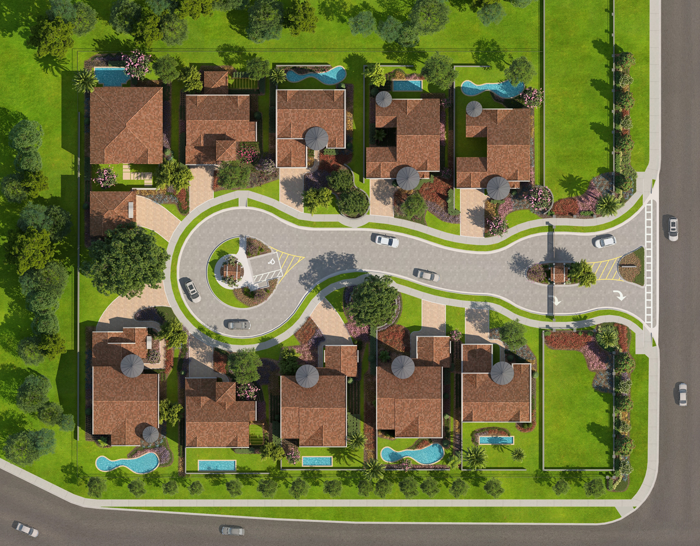
Rendered aerial site plans that make master-planned communities, campuses, and mixed-use projects instantly legible.
What a rendered site plan actually is.
A rendered site plan is a bird's-eye-view image of your entire development — buildings, streets, parking, landscape, water features, amenity pads, and phase lines — all drawn to scale and rendered with photoreal materials, shadows, and vegetation. It's the CAD site plan, brought to life so that non-technical audiences immediately understand layout, density, open space, and flow.
We produce them in two styles: illustrative (clean, semi-abstract, print-friendly with callout labels) and photorealistic (full shadow study, real tree canopies, rendered rooftops). Most clients order both — illustrative for entitlement packages and investor decks, photorealistic for sales centers and marketing collateral.
What lands in your inbox.
- Illustrative site plan — labeled, print-ready, presentation-grade
- Photorealistic aerial rendering — full landscape, shadow study, rooftops
- Phase overlay variants (Phase 1 highlighted, full build-out, etc.)
- Print files (300 DPI, up to 48″ wide) + digital crops for web and decks
- Optional amenity-level callout insets (pool, clubhouse, playground detail)
- 01 · CAD ImportYour site plan digitized and scaled.
- 02 · ModelBuildings, roads, landscape massed in 3D.
- 03 · RenderMaterials, trees, shadows applied.
- 04 · LabelCallouts, legends, phasing overlays.
Why site plans close deals and clear approvals.
A CAD site plan is a technical document. A rendered site plan is a communication tool. The gap between those two is where approvals stall and investor confidence wavers.
Entitlement ammunition
Planning commissions and zoning boards respond to context-rich visuals, not AutoCAD line work. A rendered site plan with real vegetation, shadow studies, and neighboring context turns a contentious hearing into a routine approval.
Investor comprehension in 5 seconds
A 60-acre master plan is abstract in a spreadsheet. As a single rendered aerial, an investor grasps density, phasing, amenity placement, and open-space ratio in one glance.
Sales-center wayfinding
Buyers use the site plan to orient: where's my lot, where's the pool, where's the school access? It's the single most-referenced asset in any community sales center.
Marketing consistency
The same rendered site plan drives the brochure, the website hero, the sales-center backlit panel, and the investor deck — one asset, every channel, no version conflicts.
Phasing clarity
Overlay variants show Phase 1 vs. full build-out, giving buyers confidence that the amenities they're buying into will actually be built on schedule.
Municipal and HOA presentations
A clean, labeled illustrative plan satisfies municipal submittal requirements while simultaneously serving as a presentation asset for HOA board reviews and community meetings.
Who gets the most from this service.
Every other deliverable we produce.
Ready to start your site plans project?
Firm quote within one business day. No hard sells, no long forms — just fast, straight answers.